
Drone Project Control?!
What is the place of drone project control in an organization?
Before going there, let’s agree on one thing. Project professionals in this digital era are often surrounded by new tools and technology. It’s no wonder that project teams think they must harness these tools to stay competitive.
The thinking needs to go beyond that. Project teams must be able to view these tools as a platform for enhanced project controls. For example, drones qualify as a disruptive technology and are already considered a staple tech on construction sites.
Would you like to know more about the role of drones in the project control industry? Even better, would you like some practical tips on how to kickstart your own drone program in your organization?
Then follow my drone journey below, as presented during the impactful Project Control Summit 2022. Happy learning!
My Drone Project Control Journey
My drone project control journey started in 2018, from learning how to take off a drone to driving a successful drone project control program in the company. Starting out, my primary objective was only to capture site progress videos for the client. Eventually, I evolved my skills to include Drone Photogrammetry. I was able to capture reality meshes and enhance the Building Information Modelling (BIM) workflows.
Along the way, my team and I learned that there is value for ‘Project Controls’ in these drone solutions. However, the onus is on us as project professionals to communicate to the client how exactly drones can help to achieve project objectives.
Read on below to find out what drone project control means for the project controls community.
Drone Project Control: A Mere Distraction?
The introduction of new tools and technology is a given in the project controls industry. This is true in any era, whether you are a veteran or a newcomer to the project controls industry.
And this digital era is such an exciting time for the global project professional community.
Check out Fig.1 below for some of the more popular tools and technologies, trending since 2004. How many of these tools and technology are you familiar with?

Figure 1: Technology Trends From 2004 To Present
We can see that drones have sustained public interest over the past two decades, even edging out searches on BIM!
There are no doubts drones are an interesting topic. So, let’s further explore drones and its use in Project Controls.
What are Drones?
First, a little terminology. Drones, while an extremely popular term, have other formal names:
- UAV (Unmanned Aerial Vehicle) in the US
- UAS (Unmanned Aerial System) in the UK
- RPAS (Remotely Piloted Aerial System) in most other regions.
Drone History
When do you think drones first came into being? Perhaps 20 years ago during the start of the DJI market dominance?
In fact, the earliest use of a ‘drone’ goes way back to 1935 during World War II. Someone had the brilliant idea to place a remote control on a de Havilland DH.82 Queen Bee plane. The Queen Bee was then used for target practice, how cool was that!
Modern Applications of Drone
Fast forward nearly a century later and you may be wondering, are drones still used the same way? Well, unless you’ve been living under a rock, today’s drone has so many practical applications, used in:
- aerial photography and videography
- drone racing
- surveying via LIDAR and Photogrammetry methods
- asset inspections
- agricultural analysis
- law enforcement
- logistics delivery
Modern drones are typically categorized into three categories. They are the multi-rotor, fixed-wing, and VTOL (vertical take-off) categories.

Figure 2: Evolution of the First Drone to Modern Drones
So as you can see, drones really are everywhere nowadays. We use them both recreationally and commercially. And as a fellow Project Professional, I want to share with you how I applied my practical knowledge to drone project controls.
My Drone Project Control Journey
I started out in the project controls industry very early on in my career. I was initially in the Oil & Gas industry and eventually moved to a planning and project controls consultancy. Many of our portfolio projects revolve around the infra and civil works industry.
In one of our projects, we were providing planning and scheduling services for the construction of an 80 km-long highway. At that time, the consumer drone industry was booming.
My current superior at the time thought it would be a good idea to use drone project control to supplement our monthly progress presentations.
We first captured the site progress videos of construction work ongoing on several stretches of road. Then, we edited the videos by adding music and text annotations. Finally, we presented the progress video in the next monthly progress presentation.
And my superior was right, the client absolutely loved it!
They loved the visibility that the drone videos provided them. Simply said, it was WYSIWYG – What You See Is What You Get.

Figure 3: Our Organization’s First Drone Project Control Team
Of course, choosing to fly a drone on a monthly frequency didn’t come without its challenges.
We eventually crashed a drone against a lone tree. That was mostly my fault given that I was the designated drone spotter. In my defence, I didn’t expect a huge tree to be right smack in the middle of the proposed road design. But as I learned later, we need to be extra observant of our surroundings.
Thankfully, the drone could still fly and only required a replacement camera. Eventually, a drone repair shop replaced the camera and we continued flying.
How You Can Apply Drones For Project Control In Your Projects
If the above origin story sounds familiar to you, then you are not alone. Many organizations that use drones are currently in what I would term Tier 1 of drone usage. For clarity, I categorize drone usage into three tiers of useful output for the project controls industry:
- Tier 1 – Drone usage to increase project visibility
- Tier 2 – Drone usage to generate reality meshes.
- Tier 3 – Drone usage to ‘consume’ accurate reality meshes.
I’ll explain below what it means to be at each tier of drone usage:
Tier 1 – Drone Project ControlUsage To Increase Project Visibility
In Tier 1, we are using drones primarily as a visual aid and indicator in our projects. This could mean taking a single-shot aerial image of the project site to gather a snapshot of site progress such as in Fig. 4 below. In Fig. 5, we see that the zoomed-in image has a low resolution and cannot provide many details about the project.

Figure 4: A Single-Shot Aerial Has Limited Use for Drone Project Control

Figure 5: Zooming in To A Single-Shot Aerial Yields Low Resolution Objects of Interest
Drones can also be used to capture a fly-through video. This edited video can then be used during weekly close coordination meetings between interfacing disciplines such as in Fig. 6 below. Notice how text annotations on the progress have been added to the video.

Figure 6: Drone Project Control – Monthly Site Progress Video of Highway Project
Another use case of drone project control in Tier 1 is to perform ad-hoc inspections on the construction site. For example, in Fig. 7 below I had to take a drone video of a slanted monopole. The monopole had slanted due to the sheer weight of the sand stockpile giving movement to the monopole’s foundation.
One of the downsides of using Tier 1 (simple video capture) is that we need to pre-plan the flying shot angles and flying mission. The site issue may be rectified in the next week or so and we cannot go back in time to choose a more favourable shot.
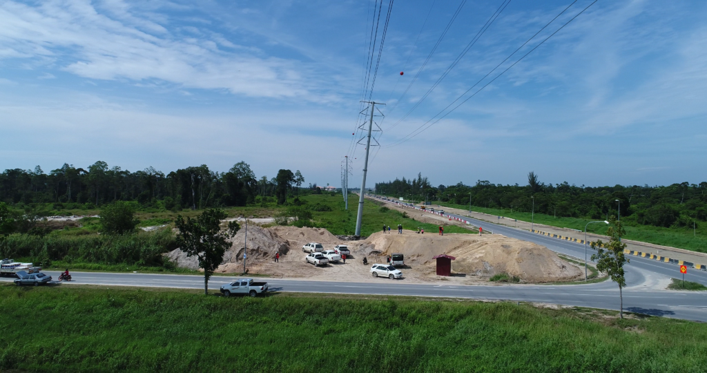
Figure 7: Drone Project Control – Inspection of Damaged Monopole
These are all real use cases of the drone on the project site. They typically require a higher degree of psychomotor skills. For example, manually flying a drone to capture aerial photographs or a progress fly-through. Many of these drones come from the consumer and prosumer fields. These types of drones are designed to be fly-out-of-the-box with minimal research required from the operator. Consumer and prosumer drones also require minimal investment. The resources involved are usually minimal too, only requiring a drone operator and a drone spotter.
Table 1 below characterizes the typical Tier 1 drone project control usage.

Table 1: Characterization of Tier 1 Drone Project Control
Tier 2 – Drone Project Control to Generate Reality Meshes
The transition from Tier 1 to Tier 2 is when the raw data undergoes post-processing to develop something entirely new. For example, raw images can be used to develop orthomosaics or reality meshes from the raw data.
There are three processes in drone photogrammetry:
- Flight Planning
- Data Acquisition
- Data Processing
During flight planning and data acquisition, we set the parameters of the flight mission to obtain photos. The drone will fly autonomously and capture these photos. However, the pilot can also use the drone to manually capture images. We see this process in Fig. 8 and Fig. 9 below.

Figure 8: Performing Flight Planning and Data Acquisition

Figure 9: Georeferenced Photos Captured by Drone
Then, the photos which are automatically georeferenced based on the drone’s GPS unit are uploaded to a photogrammetry post-processing software. The software generates the point cloud and reconstructs the 3D model or 2.5D orthomosaic outputs.
In Fig. 10 below, each of the green dots represents the altitude, longitude, and latitude of each photo taken. It is good practice to take nadirs (drone camera facing straight down), obliques (drone camera at an angle and lower altitude), and manual photos as necessary to fill in any gaps.

Figure 10: Post-Processing of Drone Photos
From here, we can then proceed to generate the outputs such as Orthomosaics and 3D reality mesh.
Orthomosaics are high-resolution 2.5D maps stitched together from several aerial images through the photogrammetry method. This allows orthomosaics to have a much higher resolution compared to a single-shot aerial photograph. The project team can then overlay the orthomosaic in their 2D construction drawings. Or they can zoom into the orthomosaic during site coordination meetings when discussing an area of interest. You cannot view objects in detail from a single-shot aerial photograph taken using a typical prosumer drone.
In Fig. 11 and Fig. 12 below, we are able to zoom in to an incredible amount of detail. This provides a lot of spatial information about the current work ongoing on-site. This serves as a basis for collaboration and discussion in the project team.

Figure 11: Drone Project Control – A High-Resolution Orthomosaic

Figure 12: Drone Project Control – Zoomed-In Orthomosaic Yields High-Res Objects of Interest
Reality meshes are 3D models also generated using the photogrammetry method such as in Fig 13 below.

Figure 13: Drone Project Control – 3D Reality Mesh of A Flyover In Progress
With reality meshes, we can perform on-the-fly measurements that even at Tier 2 are fairly accurate. For example, in Fig. 14 below, there may be a requirement to perform soil nailing and shotcrete work on the exposed slope to project the existing building construction adjacent to it.

Figure 14: Drone Project Control – Calculating Shotcrete Area on a Reality Mesh
Reality meshes are great in capturing the context of the project site. They can be overlaid in BIM models such as in Fig. 15 below.

Figure 15: Drone Project Control – Transposing Reality Mesh onto a 4D BIM Model
The BIM model with the added reality mesh ‘context’ is then used to facilitate 4D planning reviews such as in Fig. 16 below.

Figure 16: Drone Project Control – Presenting the 4D BIM Plan to the Site Team
Table 2 below characterizes the typical Tier 2 drone project control usage.

Table 2: Characterization of Tier 2 Drone Project Control
Tier 3 – Drone ‘Consume’ Accurate Reality Meshes.
What marks the transition from Tier 2 to Tier 3 is the intentional effort to develop accurate models and subsequently accurate information. The industry terms the process as ‘consuming the reality model’ to obtain useful and accurate information.
The additional effort that goes into developing these accurate models distinguishes Tier 3 from Tier 2. For example, Tier 2 teams may not use Ground Control Points (GCPs) (seen in Fig. 17 below) nor invest in PPK or RTK-enabled drones. To them, accuracy is secondary to obtaining the context meshes. Or, they may not have acquired sufficient knowledge to properly obtain an accurate model.

Figure 17: Laying Down Ground Control Points (GCP)
Often times photogrammetry enthusiasts arrive at a reality mesh and then ask, what next?
The point cloud of a reality mesh can in fact be converted to a solid 3D model in a process called Scan-to-BIM. This is where the point clouds are connected together by the software to generate solid 3D models. Fig. 18 and Fig. 19 below show the reality mesh with textures and reality mesh in its point cloud format.

Figure 18: Reality Mesh with Textures

Figure 19: Reality Mesh in Point Cloud
Table 3 below characterizes the typical Tier 3 drone project control usage.

Table 3: Characterization of Tier 3 Drone Project Control
How Can You Get Started on Drones In Your Projects?
Pitch The Idea To Management
Consider yourself fortunate if there is direct funding for your drone as stated under the project’s conditions of contract. For example, the drone could be listed as a required item in the project Bill of Quantities.
However, if that isn’t the case then chances are you’ll need to get funding from management.
It doesn’t matter if you’re proposing to purchase a small consumer drone or an entire fleet of drones with all its bells and whistles. If you cannot provide any estimate of Return on Investment (ROI) the proposal is unlikely to be approved.
Besides mentioning the obvious benefits, discuss the intrinsic benefits too. For example, the marketing team can use drone footage to create great promotional videos. The sales team can showcase landmark construction projects that were successfully executed by the organization.
Get Trained and Certified
Once management provides the green light, the next step is to undertake training on drone operation. Table 4 below shows a sample training track you may want to go through in ascending order:

Table 4: Sample Training Track for Drone Project Control Program

Figure 20: Conducting a Drone Practical Training Session
Then, depending on the regulatory frameworks in your respective regions, you may require proper certification prior to flying a drone. In the United States, this could mean getting the FAA Part 107 certification. In some regions, the existing drone regulations may be strict, but the enforcement may not necessarily reflect the same.
Regardless of the situation, every drone pilot must fly in an ethical manner, for example:
- only flying the drone within line-of-sight
- not flying the drone above 400 ft (AGL)
- not flying the drone within 50 meters of any person or structure
- not flying the drone within 3 miles of an airport
Practice, Practice, Practice
So you have received the drone training and certification, now what?
As with almost anything in life, you need practice to get better at something. So, practice on the drone simulator. Then, practice flying the drone on a weekend in an empty field. Perform more flight missions. Rinse and repeat. You should record your flight hours such as in Fig. 21 below:

Figure 21: Author’s Drone Project Controld Flight Records Synced to The Cloud
Develop a Drone Training Program
After a year or two, depending on your level of training intensity, you would rightfully have earned the label of drone champion within your organization.
You don’t want drone usage to be a one-trick pony in your company. So you might want to look into developing a drone program to sustain the entire drone operations.
As the drone champion, you are in the best position to develop this program.
Now, some organizations prefer to outsource the drone training program. This gives them breathing space to develop processes to consume drone-acquired data. And there’s nothing wrong with that. But you can also develop your own drone training program by following the steps in Fig. 22 below:

Figure 22: Steps to Develop a Drone Project Control Program
You can see in Fig. 23, Fig. 24, and Fig. 25 below some of the internal trainings that we conduct:

Figure 23: Drone Project Control Program – Learning Drone Components

Figure 24: Drone Project Control Program – Drone Simulation

Figure 25: Drone Project Control Program – Field Competency Testing
What’s Next In The Horizon for Drones?
Future Applications for Drone Project Control
So now you know how drones apply to your projects and the Project Controls industry. I hope you have been inspired to take up the mantle of drone champion in your company.
What does the future hold for drones? Well, I am looking at the widespread incorporation of Artificial Intelligence (AI) even for prosumer drones.
And it is really a great wide ocean, with endless possibilities for the potential of drones to disrupt the construction industry. And you want to be up to speed when that happens.
References:
- google.trends.com. ” Technology Trends From 2004 To Present“, 05 Apr 2022.
- Mutang Tagal, Bian. “Various Photos Related to Drone Usage”. Author’s Personal Collection, 2017 to 2022.
- airdata.com. “Author’s Flight Records Synced to The Cloud”. 05 May 2022.
About the Author:

Bian comes from a conventional Planning & Scheduling background and is also a trainer with technical capabilities in 4D BIM Planning and Advanced Drone Photogrammetry. He is currently consulting for several key infrastructure projects such as the Pan Borneo Highway project in Sarawak under PCSS Consultancy Sdn Bhd and has worked in the oil & gas industry developing maintenance schedules for a major oil and gas operator.
He holds a Bachelor of Science (BSc.) in Petroleum Engineering from The University of Texas at Austin. Bian was an invited speaker for The Institution of Engineering and Technology (IET) Evening Talk 2020.


![[Free 90-min Masterclass] How to Avoid Project Delays Turning into Costly Claims](https://www.projectcontrolacademy.com/wp-content/uploads/2025/08/September-2025-Webcast-Chris-Carson-H01-Yellow-2048x1152.jpg.webp)
![[Free 90-min Masterclass] The Ultimate Leadership Recipe for Project Professionals](https://www.projectcontrolacademy.com/wp-content/uploads/2024/08/4-2048x1152.jpg.webp)


